|
 Most algorithms used in the application are based on the properties of Kohonen artificial neural networks. As a result not just a conventional classification of data is carried out, where the monitoring of relative class positions in the feature space is difficult. In addition, the ordination of classes is achieved by mapping them upon a planar grid while preserving topological relations between classes. This method assures reliable thematic interpretation, if the input data are changed. For example, images taken under different illumination conditions or even in different seasons can be used. Most algorithms used in the application are based on the properties of Kohonen artificial neural networks. As a result not just a conventional classification of data is carried out, where the monitoring of relative class positions in the feature space is difficult. In addition, the ordination of classes is achieved by mapping them upon a planar grid while preserving topological relations between classes. This method assures reliable thematic interpretation, if the input data are changed. For example, images taken under different illumination conditions or even in different seasons can be used.
Import/export
ScanEx NeRIS works with scalar 8-bit raster layers. However, the application uses a 32-bit floating-point format for internal calculations. All layers (both input data and the processing results) have the same dimensions and are stored in a single file in STI format, which can be imported from or exported to other image formats.
ScanEx NeRIS also offers the import of raster layers in PGM/PPM and BMP formats, of scalar grids in the Surfer format, widely used by geologists, and of Arc/Info and ArcView grid formats. This allows to process not just images, but also almost any information presented in the form of a scalar grid (e.g. elevation, geophysical fields, etc.). The application can export the processing results into a vector form and convert them to various GIS packages using commonly used exchange formats such as ESRI Shapefile and MapInfo MIF/MID.
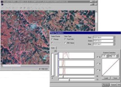
Image Visualization
The software can visualize one-channel greyscale images and colour-composite three-channel images (RGB composites) for scalar layers, as well as classified images in a preset palette and in custom palettes based on the neural-network ordination of image data in the feature space. Standard tools for channel selection, histogram transformation, gamma-correction etc are provided.
Visualisation of the continuous changes in the geographic and feature space is implemented by means of a special thematic palette creation on the basis of neural-network mapping. The user is provided with powerful tools to build thematic cartographic models in accordance with his/her expert knowledge and ancillary information.
Thematic interpretation of multi-layer data
Thematic processing of multi-layer data on the basis of neural-network ordination in ScanEx NeRIS software includes the following:
- Building a layered multi-dimensional field of characteristics
- Creation and training of the neural network
- Calibration of the neural network
- Classification for a chosen part of the image
- Implementation of contextual post-processing for generalisation of classification results
- Building thematic objects
- Vectorisation of the created object map and conversion to a standard GIS format.
The following procedures are used to build derived layers for inclusion into neural network processing:
- Rasterisation of vector thematic maps
- Calculation of principal components for a set of scalar layers
- Application of convolution filters to scalar layers
- Filtering of the scalar layers on the basis of wavelet decomposition
- Calculation of derived texture layers on the basis of GLCM (grey level co-occurrence matrix).
The procedures for contextual post-processing of classification results include:
- Creation of objects with the use of Random Markov Fields
- Classification of vector objects
- Post-processing of classification results with the use of a local window
- Generalisation of the created thematic objects
|